Three strangers met in the New York State Thruway Ulster rest area (96 miles from New York City) on the fateful day of Monday, August 29, 2011, at high noon.
They were gathered, along with many others, in front of the map of the Thruway and environs, discussing methods of traveling to New York City and nearby New Jersey suburbs.
Two seemed extremely knowledgeable; one (that would be me) was totally ignorant. I hoped to obtain useful advice about how to get to Montclair, NJ, a suburb about 15 miles due west of midtown New York.
My odyssey had begun several hours earlier, in the back roads of the small hamlet of Jewett, NY, deep in the heart of the northern Catskills, near the towns of Windham, Maplecrest, and Hunter. My wife Sue and I had rented a log cabin there for a week's vacation. We had expected to leave on Sunday, August 28. Unfortunately, a hurricane intervened.
Also with us were our daughter Georgia, son-in-law Gene, and 19 month old grandson, Sammy. They had been vacationing in the Finger Lakes region. They live in New York City (Manhattan). When we learned of the imminent arrival of the hurricane, we invited them to stay with us in Jewett, to ride out the storm in safer surroundings than NYC/NJ. In retrospect...
| |
| On Rte 23A near Hunter by Gene Sirotin | In Tannersville by Carole Sayle |
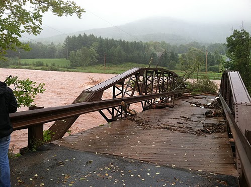
The storm came to the Catskills on schedule, beginning late Saturday night. But it produced more rain than had been anticipated. Many roads were inundated, some washed out. Bridges were destroyed. The entire main street of the town of Windham became a raging river. Power was out everywhere, including our little log cabin.
Luckily, we had enough food and water to get through until Monday, possibly Tuesday, if necessary. And it seemed it might be necessary: from car radio news (one of our two sources of useful information about local conditions), it sounded like all routes out were impassable. Our other source was eyeballing - driving out and seeing how far we could get. This source was in agreement with the first, at least initially.
By Sunday evening, when the storm was almost done, things had improved. Some roads that had been blocked became accessible as the flood waters dropped. We drove over a stretch of road that had been under 3 feet of water earlier. The stream there was now about 6 feet below road level. We were now hearing radio news reports saying roads were impassable that we knew were passable.
But receding water was not sufficient to clear roads - many of them, including the main road we took to come up the mountain (a rise in elevation of about 2,000 ft.) were totally washed out. Oops.
We hoped we could go north to a road paralleling the one we came in on. This road, Route 23, was a much better and flatter (i.e., slower ascent/descent) road. I first set out early Monday morning to see if I could get to Route 23 by going north on Route 296, the main road nearest us, through the town of Hensonville to Windham.
When I got to Hensonville, I saw a small cafe that was open, so I stopped and went in. They had a little power there from a generator, so they were making breakfast and handing it out to all comers (including me - I just took a cool cup of coffee, gratefully). A woman there confirmed that Route 23 was accessible and open for about 15 miles (about half the total distance down), because she had just driven up from there.
Another passing motorist told me his son had just headed out towards New York City on 23, so he knew it was open (somehow).
We packed up and left about 11, on a brilliant sunny day, heading for Route 23 and the Thruway south. We knew the Thruway was closed for about 30 miles, but we hoped there would be alternate routes provided.
All went well. We arrived at the Thruway rest area around noon. There we split up - I became the NJ contingent, everyone else, the NY. We were assuming our routes would shortly diverge. Did they ever.
When I left the restroom in the Thruway Ulster rest area, I noticed a small crowd to my right, gathered in front of the Thruway map. It was a place for seeking and giving advice about the long journey home. People gesticulated and talked, some excitedly, some calmly. There were some questions and answers about parts of New Jersey, but not near where I live. At a lull in the interchange, I managed to ask, "Does anyone know how to get to Montclair, New Jersey?"
Immediately, a husky middle-aged guy who had been doing a lot of talking replied, while showing the route on the map, "Take Exit 17 to Route 84 to Port Jervis, then 209 to 202 and 15. That will get you to 80, then you should be all right." Route 80 is the major highway across central Jersey, and would get me within 10 miles of my destination.
I looked at the map: Port Jervis seemed to be somewhere along the NY/NJ border, but before I got a good look, another seer, a skinny elderly gent, opined, "You don't want to do that - that's way out of the way. Take Exit 16 to 6 and the Palisades Parkway, then 46." Route 46 is a not-so-major highway that I knew to be prone to flooding even under normal storm conditions, so I was skeptical. So was Husky. He defended his choice.
"Some of that route is closed. Also, there'll be tons of traffic. Go to Port Jervis."
Reader, what would you have done?
Husky had just said, or implied, the magic words: less traffic. I hate traffic, and have spent years avoiding it. So I pretty much dismissed Skinny's suggestion. I didn't even examine the map closely to see where Port Jervis was, exactly. As they (Simon & Garfunkel, "The Boxer") say, a man hears what he wants to hear and disregards the rest.
Did I make the right choice? I still don't know.
I left the rest area at milepost 96 and headed south. Sure enough, a sign soon announced that the Thruway was closed at Exit 17, but gave no further information. Traffic was heavy but moved well - until milepost 72, which was still 12 miles above the exit. Then it began to crawl, and I began to wish I were anywhere else. Athena answered my prayers: just ahead, a few intrepid souls were turning left to go through a gap in the barrier, and taking a U-turn to the Thruway north, which was almost deserted.
I followed their lead. I planned to get off at the next northbound exit, about 5 miles away, then take the first local southbound road I could find, and hope for the best. I thought I could always look at the map on my cellphone; as I found out later, I couldn't - evidently the airwaves were swamped.
The immediate part of my plan worked well. Traffic was good, although a little slow at the exit, and the first southbound local street I took ended at Route 32, a pretty good southbound highway with little traffic.
After about 15 miles of easy riding, I reached - the suburbs. Traffic lights, and a lot of traffic. This is when I tried my map and found it didn't work. Just as I was about to despair, I saw a sign:
I had reached a point very near Thruway Exit 17 that connected with 84. This had to be a good sign, right? I managed to maneuver onto 84 West, and traffic was good again. (In the other direction, it crawled.)
On 84 I saw another sign: PORT JERVIS 37 MILES. I began to realize why Skinny advised against this route. Still, 37 miles at highway speed is only a half hour.
It turned out that the whole journey along 84 wasn't at highway speed. But it did take less than an hour. I passed the exit for Port Jervis and saw the exit for 209. Just before reaching the exit, I hit a bridge over a fairly substantial body of water. On the other side was a cheerful sign:
Whoa - should have looked at that map more closely. "Port" Jervis? Must be on a body of water with a connection to the outside world - what could that body of water be? Maybe the Delaware River? Bingo.
So now I was in good old Pa., headed south through the quaint little town of Milford. Should I just keep going south to 80, and wind up crossing New Jersey east-west twice? Or try to follow Husky's directions - maybe his route cut across diagonally and was shorter.
I took the next left, which was across another bridge and back to NJ on Route 206. I found a gas station and stopped for updated directions. Seems 206 was good, but Route 15, which was next on Husky's list, was closed (something about flooding): ah well, nobody's perfect. Not to worry, though: 206 itself eventually hit 80, just a little farther west (about 10 miles).
My local adviser cautioned me, though: "Got road rage?"
I of course replied, "Huh?"
Said he, "If you have road rage, better not go that way. There's about 3 miles of stop-and-go traffic. Everybody's going that way."
"Oh, OK" I said. "I'm pretty laid-back today."
"Good luck."
And off I went - it was pretty much as he said. Fast, slow, fast - the 3 slow miles were in the middle. At last, I was on Route 80, roughly 35 miles from home, after 4 hours of travel.
Things moved well again, but I began noticing a lot of closed exits, due to local roads being impassable, including Route 23 (a road near me) and Route 46 (Skinny's suggestion - remember?)
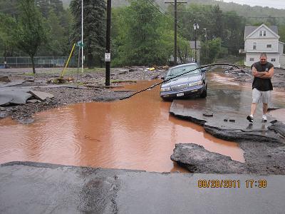
Traffic slowed, whether due to extra people stuck on the road from lack of exits, or the whims of the gods. It became as bad as the Thruway, but here there was no exit. I ate stale crackers, drank stale water (melted ice cube water from after the power failure) and listened to the radio. It seemed there were a lot of closed roads, still millions without power, 40 dead, and beautiful weather.
After about an hour of this, I saw the exit sign for Route 280. Ordinarily, I would take this, as it goes within about 4 miles of my home, but I remembered hearing that parts of it were closed, and I didn't know which parts. I planned on taking the Garden State Parkway, which was still a long way down the road. But the traffic in the exit lane to 280 began moving faster and faster, so I decided to go with the flow, and headed off onto 280. Good choice - 280 moved at normal highway speed.
The rest of my journey, about 12 miles along a route I had driven before, was unobstructed and moved well. After 6 hours and 210 miles (usually 2 1/2 and 125), I was home.
Visions of the raging Schoharie Creek, the wine-dark (muddy brown of old white wine) Schoharie Creek, with its cargo of drowned bridges and drowned towns, still filled my head, but I was home.